 MENU
MENU
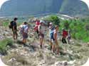
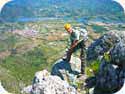
Pyrenees Hiking and Climbing Routes
Since 2007 our club has been making annual visits to the Spanish Pyrenees. The drive time is just six hours from the Alicante Province.
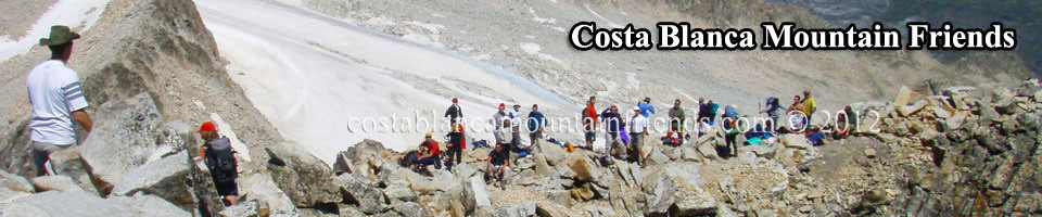
Our base is normally in the Jaca area and this provides us with good access to most of the major peaks. July is an excellent month for hiking and climbing as most of the snow has melted by this time and the stormy mountain weather that occurs in August is avoided. 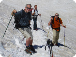 However, even in July many of the peaks and canyons will contain snow and glaciers. In particular, Pico de Aneto with a 3 km glacier. Crampons and ice axes should be carried on such routes.
Most of the peaks that we have climbed are listed below in chronological order although we have climbed most of them numerous times. Finally, a good topographic map is required and we recommend the Mapa excursionista 1:25.000 series.
July 2007 Expedition
Peña Oroel. Height 1769m
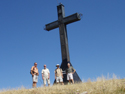
 Overlooking Jaca from the south the large steel 9 meter cross on the summit can be seen from the town centre on a clear day. The hike starts from the Merendero del Mirador de Oroel along a well marked track that zig zags up through a forest for about one hour. The remainder of the hike is along the final headland to the cross.
Easy hike. Distance 10km. Duration 3.5hrs. Ascent 583m.
Pico de Anayet. Height 2574 metres
 From a parking area on the N330 (GPS 30T 0703595 4739160) just south of Candanchú, follow the GR11 signs to Formigal direction. The route follows the Canal Roya and Río for about 7km. At La Rinconada and the head of the valley a zigzag track rises sharply to the right to a shelf where the lakes of Anayet are located. Then head west on a small track and continue the climb until the high crest and summit are seen on the right. The final ridge scramble is exposed and via a steel security cable. The descent scramble in misty weather is very dangerous.
Strenuous and exposed. Distance 18km. Duration 7.5hrs. Ascent 1184m.
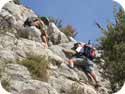
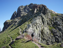
Peña Collarada. Height 2883 metres
 The climb can commence from Villanúa Village at 1017m (GPS 30T 0707239 4732387) or by driving to the La Trapa track at 1220m and parking at the barrier. Our normal ascent is through the forest with steep sections to Llano de los Güeys. From this point more steep climbs lead to a rock barrier scramble. This is followed by more steep climbs until long slopes are reached with the summit in view. Rocky steep tracks lead to the base where the white summit dome can be seen and is reached after a short scramble. Our descent is via El Trapal refugio. Strenuous. Distance 22km. Duration 8hrs. Ascent 1866m.
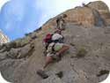
Pico de Aneto. Height 3404 metres
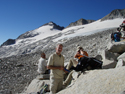 Our ascent from the refugio was on the 31st July 2007 with ideal weather conditions. Starting at 0630 hrs our first challenge was the Portillón Superior where access is gained to the glacier. To cross the 3km section of glacier safely it was necessary to wear crampons but our ice axes were not needed. Near the end of the glacier below Punta Oliveras a steep climb of 100m takes you to stony ground where crampons can be removed. Further climbing takes you to the Paso de Mahoma which involves a 30m very exposed scramble to the summit. Some climbers do not cross it.
Our ascent time was 5.5hrs. Mapa excursionista Aneto Maladeta 1:25.000
Refugio de la Renclusa. Height 2140 metres
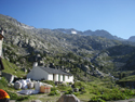 Ideally situated at the base of Pico Aneto this refugio is just metres away from the main ascent track. The services include a restaurant, bar, rental of climbing equipment and 44 bunk beds with mattresses, pillows and blankets only. Sleeping bags or sheets are required and towels and soap.
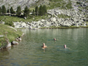 The cost for our group of 4 climbers in July 2007 for one night was 210 Euros and included dinner, breakfast, packed lunches and the hire of crampons and ice axes. It’s advisable to reserve accommodation well in advance of your visit. After your climb you can bath in the Ibon de la Renclusa at 2200 metres.
Getting to the Refugio
From Benasque head north on the A139. Turnoff to the right at K71 and follow this small road for 300m until you arrive at a car park. If you are staying at Hotel Hospital de Benasque then you are permitted to drive direct to the hotel car park. Otherwise it’s necessary to park here and take a bus to La Besurta which is about 6km. From La Besurta at 1898m the hike to the refugio takes about 40 minutes with an ascent of 242m.
Refugio GPS 31T 0307561 4726973
July 2009 Expedition
Peña Oroel. Height 1769 metres
 Overlooking Jaca from the south the large steel 9 meter cross on the summit can be seen from the town centre on a clear day. The hike starts from the Merendero del Mirador de Oroel along a well marked track that zig zags through a forest for about one hour. The remainder of the hike is along the final headland to the cross.
Easy hike. Distance 10km. Duration 3.5hrs. Ascent 583m.
Bisaurin. Height 2670 metres
 Located in the Sierra de Secús our access was via Refugio de Lizara. From this parking point there are a number of tracks but follow the GR11.1 for about 5km until the steep summit track is reached. To descend in a circular route hike east about 500m to pick up the first track which drops sharply down the north face. There is second track about 500m further east but both are steep and with ice and snow in mid July. Once in the barranco continue the circuit passing Caseta de Vernera. Use Mapa y Guía Excursionista E-25 Valles de Ansó y Echo. Strenuous. Distance 14km. Duration 6hrs. Ascent 1200m.
Pico Llena del Bozo. 2559 metres
 Located in the Sierra de Aísa our access was via El Rigüelo in the Valle de Aisa. From this park place the track heads north crossing over the GR11.1. This track is covered with ice and snow in mid July and eventually leads to the col between Bozo and Llena de la Garganta. The track to the Bozo summit is not clearly marked but eventually we found some cairn markers. We then descended to the col ready for our ascent of the Garganta. Strenuous. Distance 16km. Duration 9hrs. Ascent 1434m.
Pico Llena de la Garganta. 2597 metres
 From the col of Bozo we commenced our climb of Garganta. There is no clear route and no marks but after some scrambling we saw a few cairns. Our climbing soon developed into a grade 3 scramble and it was necessary to make new cairns ready for our route down. There was no snow in mid July. Rope back up is advisable. See Bozo details above for route information. Exposed scramble.
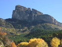
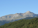
Pico de Aspe. 2640 metres
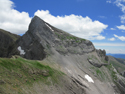
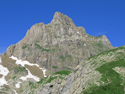 Our climb started from the main ski car park area in Candanchu. The route traverses through ski areas and becomes very steep. Eventually a point is reached with views of Pico El Sombrero, Pico de la Garganta de Aisa and Pico de Aspe. See photo below. From here you descend to the barranco and then ascend to the Aspe via a steep glacier. We managed this in July without crampons but it was not easy. Above the glacier you reach a col to the right of the Aspe and from here keep to the left and follow some cairns. Our return route was the same as our ascent route. Strenuous. Duration 8hrs. Ascent 1150m.
Pico El Sombrero. 2562 metres
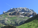
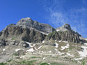 Pico de la Garganta de Aisa 2502m and Pico de Aspe 2640m as viewed from the direction of Candanchú. See route details above.
Mallos de Lecherin. 2452 metres
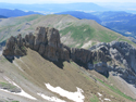 Departing El Rigúelo in the Valle de Aisa and after a very steep climb we reached the Mallos. Time did not permit us to climb the rock and from here we continued on to Pico de la Garganta de Borau, El Sombrero, and Pico de la Garganta de Aisa. See continuation of our day and the other peaks below.
Pico de la Garganta de Borau. 2566 metres
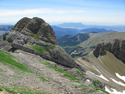 Our approach was from the right and the ascent is a grade 2 scramble. The route to El Sombrero is difficult to find and involves descending Garganta to a ledge above the col. Follow the ledge in a clockwise direction until the ridge of El Sombrero. From Sombrero we descended to Pico de la Garganta de Aisa 2502m. The track for descending the Aisa is difficult to find and dangerous. Finally we reached the Garganta de Aisa and El Rigüelo after crossing several glaciers in July. The four combined peaks in one day took the following time. Very strenuous. Distance 18km. Duration 9hrs. Ascent 1350m.
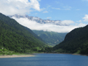
Lac de Fabreges and Pic de la Sagette 2031 metres
 During our rest day we drove north from Jaca and into France via the N134. From Escot we turned east on the D294 and over the Col de Marie Blanque. At the D934 we headed south passing through Laruns. Further south the beautiful Pic de la Sagette and Lac de Fabreges came into view. At the Spanish French border post of El Portalet we drank a beer with clear views of the menacing Pic du Midi d'Ossau. Over the border we drove on the A136 through El Formigal and then headed back to Jaca on the N260 and N330. A beautiful recommended tour with a duration of 8 hours including lunch in France.
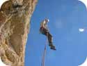
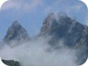
Pic du Midi d'Ossau. 2884metres
 The mountain is located in France just a few kilometres from the Spanish–French border post El Portalet. The Pic looks menacing in bad weather but is climbable in good conditions. The ascent has sections of grade 2 to 3 scrambling and the descent requires two 25 metre abseils.
Due to poor weather we ran out of time but will climb it next year.
July 2011 Expedition
Pic du Midi d'Ossau. 2884metres
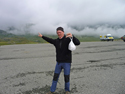 Another year and another attempt to climb the Pic. Jeremy's face tells it all. Two days of bad weather thwarted our well prepared plans and the Pic was not even visible from the park area. Our reservation at the Refuge de Pombie had to be cancelled.
All heights, distances, times, grades and equipment and other information listed on this page are provided in good faith as experienced by the author but may include errors. Anyone attempting these routes should verify the information before commencing the activity in case of errors, route modifications or geological changes.